High desert hiking with Steve

All directions to hikes, trail heads, parks and campgrounds mentioned in this blog will be written as if the point of departure is always St George, Utah. Since St. George is my home it only makes sense to direct all outings from here, rather than trying to go from many directions.

Anyone visiting the Southwestern region, from anywhere in the world, would be smart to also make St. George, or almost any of the smaller cities of Washington County, their temporary base of operations while vacationing or sight-seeing in this region. This County is home to, or close-by, many of the most popular parks, both State and National. The Grand Canyon, Bryce Canyon, Zion National Park, and many lesser known but equally interesting places are all just a short drive away from these communities.

My intention, in this blog, is to bring out some of the lesser known places of interest, things to see, as well as the unique history of the region. Emphasized in this blog will be the little known trails, interesting landmarks, scenic places, and the historic artifacts and writings of the Native Americans that have inhabited this area for centuries. Also of interest will be the European explorers that first came to this region in the Sixteenth Century, they certainly left their mark here.

Sunday, December 2, 2012

Whitney Pocket / Little Finland


Whitney Pocket;

Whitney Pocket is a great hike or outing, suitable for beginners, less experienced hikers, or even for a family outing.  The Pocket is located in southeastern Nevada on the small peninsula of desert bordered on the west by Lake Meade, Arizona to the east, and the Colorado River to the south. The only paved entrance or exit is from the north, there is a small dirt road crossing into Arizona but four wheeled drive only recommended. 
Four wheel drive vehicle is not necessary to visit the C.C.C. dam or the Pocket, but high profile vehicles would be best on these dirt roads, the family sedan is going to encounter problems with the small washes across the roads and deep ruts in places.
From Interstate 15 exit 112 is the exit used to get to Whitney Pocket. The exit is about 60 miles north of Las Vegas, and about 8 miles south of Mesquite, Nv, 45 miles south of St. George, Utah. After turning off on exit 112, proceed toward Bunkerville about 3 miles, after crossing the Virgin River make a right turn on the paved road paralleling the river and follow it about 25 miles.
Approximately 25 miles after turning onto this road there will be a crossroad, with a small B.L.M. parking area located on the southwest corner of the intersection. The dirt road to the west leads into Arizona, but about 1 mile from the intersection there is a dam on the left side visible from the road and a camping area just beyond. This is a good place to stop and investigate.
After a close-up look at the old dam proceed back past the B.L.M. parking area and continue westward about two to three miles to Whitney Pocket, where again, there is a small B.L.M. parking area. The trailhead leads out of the parking area toward the south, about one quarter mile to the Pocket opening.
Inside the Pocket the trail no longer exists, you’ll need to veer leftward along the rock wall, watching for petroglyphs and pictographs all along the way. You eventually come to groups of well preserved petroglyphs on many rock walls and 
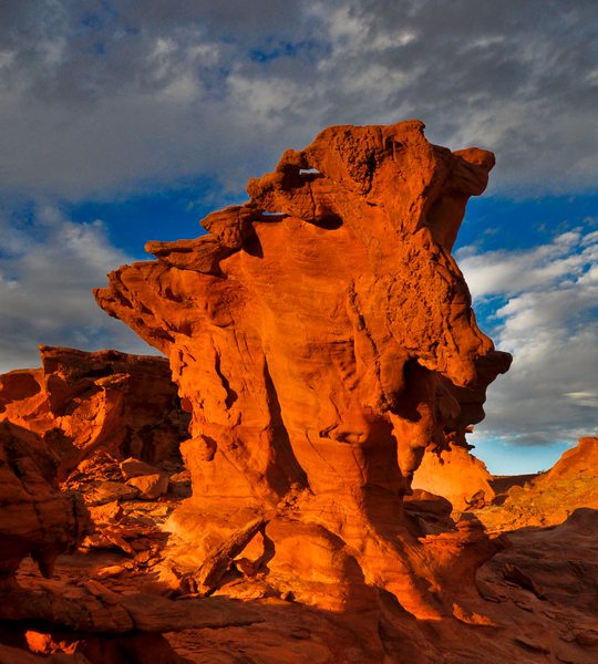
large rocks. Also very colorful scenery, red and white Sandstone, blended together in the rocks and quite a lot of vegetation, many varieties of cactus, including Barrel Cactus, various wildflowers and Joshua trees. Wind and water erosion has created some very unusual rock formations as well.
As you leave the Pocket parking area, proceeding back to the first B.L.M. parking area, you may choose to turn right back onto the main road coming in from Interstate 15. Proceeding south approximately 5 miles, you come to Mud Wash, a very rough, dirt Jeep trail turning off to the right toward the west. Mud Wash will take you to an area called Little Finland, a very remote, baron, scenic red rock area. Very few people visit this area, due to the difficulty in finding and reaching it.
On the way out when you reach the main road you can turn right, back toward the south, drive a couple of miles and visit the Devil’s throat. The Devil’s Throat is a huge sink hole in the desert, nothing really very scenic or interesting about it other than it’s just a sudden hole in the middle of nowhere.
Precautions should always be taken on any outing in the desert, plenty of water, extra food, first aid supplies and always leave word with someone, your expected route and return time. Dangers to watch for include, snakes, spiders, scorpions, and even Gila Monsters, this is a very remote and unpopulated area. Enjoy your visit to this area.


      The C.C.C. built dam is just off the dirt road, easy access with a campground nearby
                  In the background the dirt road leading back to the main road is clearly visible
               The dam is approximately 50 to 60 feet wide, 20 feet high, and about 2 feet thick
 The lake-bed where the water was stored behind the dam is dry now, the dam gate is locked open and no water is restricted behind the dam. It was probably built and used as a flood control measure.
 The canyon behind the dam is narrow but reaches way beyond visibility, this little dam probably created quite a long but narrow lake when it was in use.
 Built during the Great Depression, the workmanship was very good, now more than 80 years old this dam is still in nearly perfect condition.
 Most petroglyphs are very difficult to read, there's always doubt as to what the artist was trying to convey. This one is pretty obvious, they drew in the rocks what they saw around them, Mountain Sheep, Desert Tortoise, Man Falling from a high place.
 Some of the etchings are not so obvious, what must have been important enough for someone to spend hours creating, leaves the modern day viewer wondering what it all means. Some symbols appear often in many etchings, the spiral, seen to the right on the rock.
 I know it's not what this is really trying to convey but it almost seems like this is depicting a family outing in the park. You have two children playing tether-ball, other children being tended by the adults, and you have a swing set. Click on the picture, enlarge it and pick all these things out.
 Library Rock, called that for obvious reasons. If you look very closely to the far right you can make out a cross. This tells me this etching was done after the Spaniards came to the Southwest and introduced Christianity into the Native American Culture. There are also the usual, Desert Tortoise, Bighorn Sheep, and the foot-prints.
 The rocks and surrounding hills in the Pocket are very colorful, with red veins running through the white Navajo Sandstone.
 This is a pictograph, different from a petroglyph in that it is painted onto the stone rather than being etched into the stone. Below is what I believe they must have used to make the coloring agent, the paint. I think they must have ground the colorful stone into a powder and moistened it with liquid to make the paint they used for drawings. Again, the above drawing is what appears to be a Christian Cross.

 This is the opening to the Pocket, it is the passageway in and out. When you crawl through this opening the Pocket becomes visible, but from this side of the opening you'd never know it was there.
              Wind and weather has eroded the soft Navajo Sandstone in very beautiful ways.
 This was probably used as a family sleeping area, providing a little protection from wind and such.
 This was taken using zoom, it was located very high in the side of a cliff. I didn't see any eagles but these nests were obviously built by a large bird.
    Vegetation in the area includes many types of cactus as well as the Joshua Trees pictured here.
The next few pictures were actually taken by George Harmon, a fellow hiker. He was gracious enough to give me permission to use these photos in this blog post.
 Little Finland, where these next few pictures were taken, is a very desolate but beautiful area. I would guess most of the erosion that caused these rock formations was caused by wind, very little rainfall out here.
 As you walk around this area you can't help but wonder, what kind of forces could have possibly caused this kind of scenery.
                                  Again, its just amazing rocks could form in this manner
                                                           A stand alone rock.
                   A stand alone palm tree. Looks a little out of place out here on the Martian Landscape
                           Every direction you look out here is a new surprise and a new wonder.

                                                       A rock with a skylight.
                              Yes, in every direction, even upward, there are views everywhere.
                                     And then the setting sun provides another wonderful view.

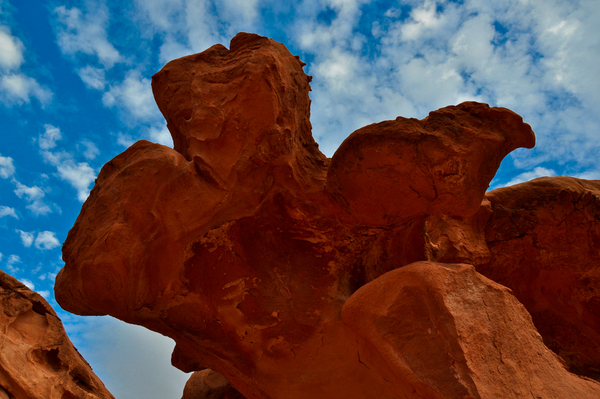
                                The pointing rock, showing you the way back home I suppose.


No comments:

Post a Comment