Awesome Chasm is a hike I would rate as strenuous, very difficult, somewhat dangerous, but well worth the effort for anyone who is in shape, and not afraid of high risk.
I did this hike in late December, making it somewhat more dangerous and difficult than it might be in summer months. We had to deal with ponds of ice, snow and ice on the already slick rock, and cold winter temperatures, making hands and fingers less agile effecting our ability to climb. However, in the summer one would have to deal with ponds of water, and mud, rocks hot to touch, and possible 110 degree heat during the day. Not to mention snakes, scorpions, spiders, and who knows what else. At no time of the year would this be an easy hike, anyone who is not confident in their rock climbing ability and personal stamina, reflexes, and balance, should not attempt this hike.
The trail begins about nine miles north of St. George, Utah, off Highway 18, one eighth of a mile north of the Diamond Valley turnoff. There is a small parking area on the east side of the highway, approximately eight to ten vehicles could be parked there. Here, you simply walk across the highway and start your hike.
Below, the trail is not marked but is fairly visible easily followed, to a dry flat wash where you take a right turn and walk in the wash approximately one quarter mile. The sand both in the desert trail and the wash is deep, difficult walking most times. We were lucky on that leg of the hike, being a cold December day the moisture in the sand was frozen making the walk easier.
As you walk in the dry wash it takes you past the rocks shown below. Larger and much taller rocks will be to your left. Those taller rocks are where you're going.
Below, the trail clearly leaves the dry wash and turns you directly toward a wash that comes down from the taller rocks, the trail will lead you right into the wash, shown below. To the right at this point, there is a panel of Petroglyphs on the face of a rock not far out of the way.
These Petroglyphs are weather beaten and faded, but still very visible. I found no unusual etchings there, mostly the same drawings you see frequently on the rocks of this area.
I know these lines and apparent scribblings must have meant something to the person who spent hours etching them, but it sure is hard to figure what they could represent. As much work as it obviously was to create these lines, they must have some meaning.
Below is one image I haven't seen elsewhere, it kind of looks like a candle holder, or maybe a pitchfork. I'm sure it wasn't meant to represent either of those things but it is a little different.
Above is an exception to what I said about nothing unusual. a Pictograph. Not many Pictographs exist out in the open like this. Being painted on instead of etched into the rock, they usually weather and fade quickly
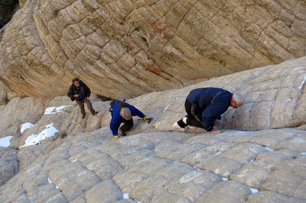
Above,, We get our first look at the obstacles we'll be facing the next few hours, icy ponds with steep slick rock climbs behind almost every pool.
Above, we get our first taste of what we're in for, precarious finger holds and crevices only the toes of our boots and shoes can barely catch a hold on. A fall means almost certain injury, it would only be a matter of how serious the injury.
Above, I can almost read his thoughts at this time. I know for certain what I was thinking by this time. I really don't want to go on with this hike, but if I turn around now, I'd have to go back down what I just came up. As hard as the climb up was, I thought climbing down would be even harder. I went on, and so did Brian.
Above, Regardless of how difficult this hike was, it was beautiful. The recent dusting of snow and the freezing night-time temperatures created a winter spectacle.
Above, Between climbs there would be short spaces where we had just a leisurely walk before coming to the next climb. the scenery made the hike worth the effort.
Above, I even discovered an arch, I claimed it. I have no doubt that soon people will be traveling from near and far to see, "Jennings Arch", "the world's smallest arch". Or maybe not.
Above, There are pools, ice, every few feet all the way up this wash. Below, we stopped at a few of these frozen ponds for play.
Below, after the short "Play break" and a little relatively flat walking conditions, it's right back to the steep rock climbing. There was many places where the first person going up would have to brush snow from crevices to make finger holds sufficient to use for climbing.
Above, This was nearly at the top of the wash, it's like nature saved the hardest for the very end. I was so happy to be up to the top of that wash. As seen below.
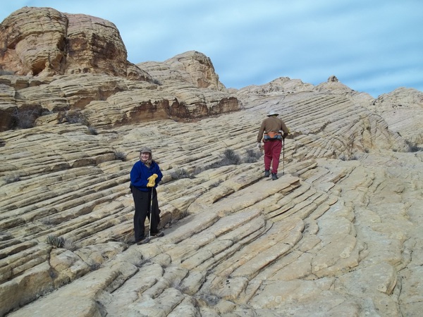
We stopped to pose for pictures and relax a little before going on, we were still a long way from the Chasm.
Above, Once we exited the wash the landscape changed, the rocks were different and we could walk upright, it felt good.
Below, Even though we were walking upright, we had to pay attention. The trail is not marked up here in any way, you have to just keep always upward in direction, the Chasm is at the highest point on this mountain.
Below, The landscape up here is rock, always rock. It may be white or red or black, it may be layered or appear as small blocks or jagged rough, but it's rock, very little vegetation of any kind.
Below, Occasionally it was as though nature made a little walkway just for us.
Above, In the midst of all the flat, white sandstone, every now and then you find a rock like this, that just doesn't seem to belong here, just sitting there.
Above, I never stop wondering as I see formations like this, what natural occurrence could have possibly caused rock to form this way.
Above, Pine Valley Mountain in the distance. This area is high enough to give you a good view of the surrounding terrain.
Still climbing higher, but almost to the top now, just a little higher.
Above, this is the top. On the other side of that wall of rock is the Chasm. We took a little break here. Below,, Meredith and John were our guides on this hike, I was very impressed with their knowledge and hiking abilities.
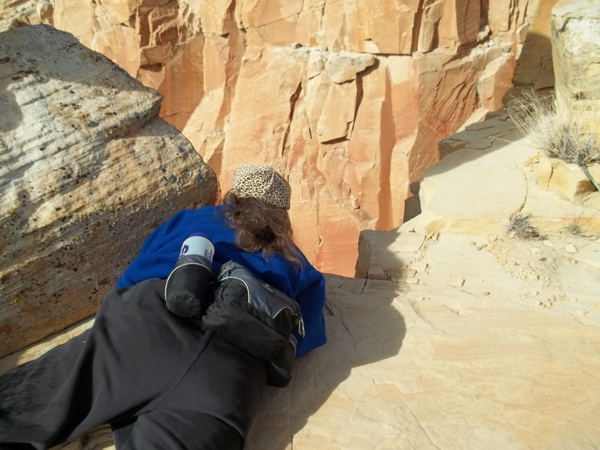
Above, Meredith wants to photograph the Chasm. She lies on her belly and crawls carefully to the edge.
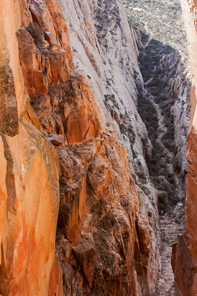
Above, This is the Chasm, the truly Awesome object of this hike. It is a shear drop of several hundred feet from here. At the bottom of the chasm the floor of Snow Canyon begins.
Above, Meredith is posing on the edge of the Chasm, she came this far she wants proof she was here.
Above, Yvonne also wanted proof she was here, I didn't care if I had proof or not, I was not going near the edge of that cliff.
Above, We stayed at the top a while, just exploring, taking in the views and posing for pictures. In the background you see Snow Canyon.
Above, To the east is the Diamond Valley Volcano. Just below the Volcano highway 18 is visible.
Above, and Below, We took pictures of the views and landscape.
Above, Still exploring somewhat but starting our descent by now. We would be going down the mountain by a different route than we came up, I was sincerely hoping it would be easier than the ascent.
Above, Just a few more photos, it just seems like you can't get enough pictures here to fully show the extreme terrain and wonderful views.
Above, Heading toward the east wash now, it will be our route of exit. Starting to get back into the shaded areas where ice and snow doesn't melt so quickly.
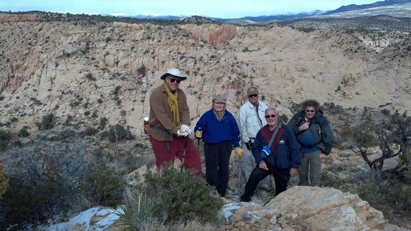
Above,,, We all posed for one last photograph, from left to right is John, Meredith, Doug, Steve, Brian. Yvonne, shown below, was operating the camera.
My sincere thanks to all these fellow hikers, many of the photos in this post were provided by them, and although many of us had never met before this day, they were a fine group of hiking companions.


No comments:
Post a Comment